简体中文
繁體中文
English
Pусский
日本語
ภาษาไทย
Tiếng Việt
Bahasa Indonesia
Español
हिन्दी
Filippiiniläinen
Français
Deutsch
Português
Türkçe
한국어
العربية
Cyclone Kenneth: East Africa residents brace for deadly storm
Abstract:Media playback is unsupported on your device Media captionNick Miller reports on the impacts expec

Media playback is unsupported on your device
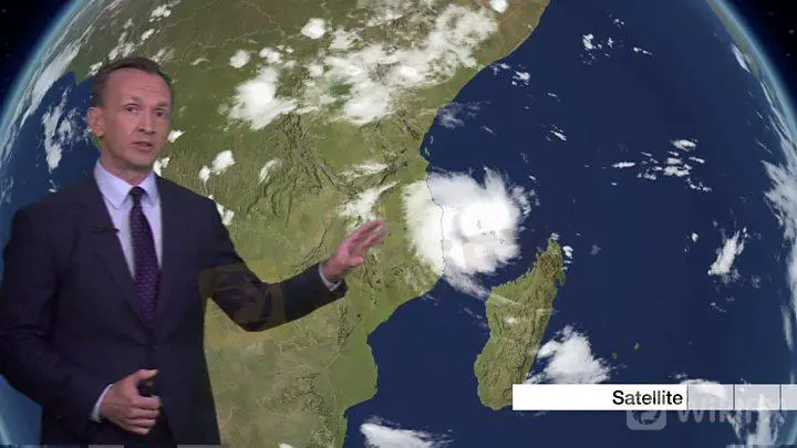
Media captionNick Miller reports on the impacts expected from Cyclone Kenneth
Residents in Tanzania and Mozambique are bracing for the touchdown of Cyclone Kenneth - which is barrelling towards land with winds of 205km/h (125mph) and torrential rain.
Communities in the southern Tanzanian region of Mtwara and in northern Mozambique are being warned to seek higher ground and shelter.
UN officials say they fear it could mean a “humanitarian catastrophe”.
Last month, Cyclone Idai caused hundreds of deaths in the region.
More than 900 people died when the storm brought devastation to Mozambique, Malawi and Zimbabwe.
At least three million people were left in need of humanitarian assistance.
Africa Live: More on this and other stories
Cyclone Idai: What the aftermath looks like
How prepared was southern Africa for Idai?
The latest system is expected to hit further north than Idai, forecaster say.
What is the latest?
Kenneth, an intense tropical cyclone, is expected to make landfall on the north coast of Mozambique on Thursday evening.
Forecasters warn it is likely to be slow-moving, meaning heavy rain is expected to fall on the area for several days.
Flights have already been cancelled and schools closed as Mozambique braces for the storm to hit.
Its violent winds and rains hit the island nation of Comoros overnight. Authorities there say the storm killed at least three people as it swept through.
The country's two main islands saw power outages and trees downed in high winds, Reuters news agency reports.
Hurricanes, typhoons and cyclones explained
The International Federation of Red Cross and Red Crescent Societies shared images of the damage on social media.
In a tweet, the group confirmed it had volunteers on the ground assisting communities.
Skip Twitter post by @IFRCAfrica
Devastating images from #Comoros following #CyloneKenneth.
Homes and roads are damaged and destroyed, telephone poles and trees are down. Red Crescent volunteers are supporting the urgent needs of communities, providing first aid and assessing needs on the ground. pic.twitter.com/Fl0t5C3vh1
— IFRC Africa (@IFRCAfrica) April 25, 2019
Report
End of Twitter post by @IFRCAfrica
Late on Wednesday, the head of the UN Office for Disaster Risk Reduction said she feared the region faced “another humanitarian catastrophe”.
Mami Mizutori shared an image which showed the large storm system on Twitter, warning it was already comparable in intensity to Cyclone Idai.
There is no previous record of hurricane-force systems ever hitting the region so far north before, BBC Weather reports.
The storm is expected bring 1m (3.2ft) of rain to some areas of Mozambique - with storm surges expected of 3-5m in places.
Despite Zimbabwe being further inland, officials there say they are still putting their disaster management agencies on alert.
“Drawing lessons from Cyclone Idai we cannot take chances anymore,” Director in the Department of Civil Protection Nathan Nkomo said.
Disclaimer:
The views in this article only represent the author's personal views, and do not constitute investment advice on this platform. This platform does not guarantee the accuracy, completeness and timeliness of the information in the article, and will not be liable for any loss caused by the use of or reliance on the information in the article.
WikiFX Broker
Latest News
JUST Finance and UBX Launch Multi-Currency Stablecoin Exchange
XM Revamps Website with Sleek Design and App Focus
Global Shift in Cryptocurrency Taxation: Italy and Denmark Chart New Paths
Webull Introduces 24/5 Overnight Trading to Extend U.S. Market Access
TradingView & Mexico’s Uni. Partnership, to Enhance Financial Education
Something You Need to Know About SogoTrade
eToro Launches Global-Edge Smart Portfolio: A Balanced Approach to Growth and Stability
Darwinex advises traders to update MT4 & 5
Revolut X Expands Crypto Exchange Across Europe, Targeting Pro Traders
Broker Review: Is Exnova Legit?
Currency Calculator


